EXPLORE the Uvs Nuur Basin with this slideshow, check the location map and get all the facts and information below.
For slideshow description see right or scroll down (mobile). Click to view slideshow

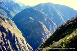
Location and Values: The Uvs Nuur Basin is a complex serial site straddling the international border between Mongolia and the Russian Federation in eastern Eurasia. The world heritage site covers 12 separate areas in a semi-arid natural basin bounded by high mountains that drain into the large saline lake of Uvs Nuur. The 12 protected areas are representative of the major biomes of the region, varying in size from 8 km2 to 4,243 km2 and covering a range of elevation from 759m to 4,116m. The 12 components are contained within an area roughly 400 km west-east and 200 km north-south between the biogeographical provinces of the Siberian Taiga, the High Altai and the Mongolian Steppe. They support a great diversity of ecosystems including cold desert, desert-steppe, steppe, taiga, moorlands, alpine tundra, boreal, deciduous and floodplain forests, lakes, saltmarshes and snowfields.
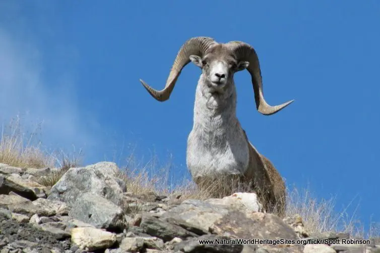
The Uvs Nuur Lake (Lake Ubsunur) is important for migrating birds, waterfowl and seabirds, while the steppe and desert areas harbor a number of rare gerbil and jerboa species as well the marbled polecat (vulnerable to extinction). The surrounding mountains provide an important refuge for globally endangered species such as snow leopard as well as Argali mountain sheep, Siberian ibex, bearded vulture and brown bear.
Conservation Status and Prospects. According to IUCN’s Conservation Outlook Assessment (2020) the conservation status of the Uvs Nuur Basin is ‘good, with some concerns’. The IUCN report notes that conservation of the site benefits from its location in a region that is sparsely populated and lacking industrial development. However there is concern that an increase in the number of domestic livestock, overgrazing and expansion of rangelands is degrading the natural habitat of endangered species, such as the argali mountain sheep. In addition, the impacts of climate change are already apparent with significant glacial retreat and desertification. Other threats that have not yet been properly assessed include forest fires, illegal hunting, illegal logging, pollution of rivers and collection of wild plants. There are significant constraints on management effectiveness resulting from financial and staffing shortfalls.
Links:
Google Earth
Official UNESCO Site Details
IUCN Conservation Outlook
UNEP-WCMC Site Description
Birdlife IBA
Slideshow description

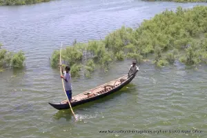
The slideshow ‘tells the story’ of the Uvs Nuur Basin with a portfolio of photos that illustrate its landscape features and some of the typical plants and animals. It starts with general views of the Mongolian steppe in this part of the country, and the communities with their domestic livestock and characteristic round yurts. Several of the smaller lakes are shown to provide general context for the broader Uvs Nuur Basin, although these are not necessarily designated protected areas within the world heritage site. Throughout the slideshow, some of the typical plants and animals of the Uvs Nuur Basin are shown, including (in order of appearance): Argali mountain sheep, bearded vulture, Siberian ibex, Pallas’s cat, marbled polecat, toad-headed agama lizard, gerbil, Pallas’s pika, northern three-toed jerboa, upland buzzard, Altai marmot, brown bear and snow leopard.
The following Flickr photographers and other sources are acknowledged with thanks for their contributions to this slideshow (as credited in the watermark of each photo): Alastair Rae, Sergey Volkov, Scott Robinson, Michael Heyns, catnip254, Andrew, Josh More, Land Rover Our Planet, Cloudtail the Snowleopard, US Embassy Pakistan, Georg Sander, David Ells, Eric, kylepounds2001, Malcolm Skinner and Rita Willaert. Note that some of the close-up photos of animals are from other locations (including animals in captivity), and these are included to illustrate species found in the area. In some cases, these may belong to different sub-species and/or vary slightly in appearance from individuals from the Uvs Nuur Basin.
Factfile
Website Categories:
Lakes, Freshwater Wetlands & Glaciers;
Temperate Grasslands, Steppes, Shrub-Lands & Tundra;
Area: 8,981 km2
Inscribed: 2003
UNESCO Criteria:
- Ecological processes (ix);
- Natural habitat for biodiversity (x);
- Significant number of rare, endemic and/or endangered species (x)