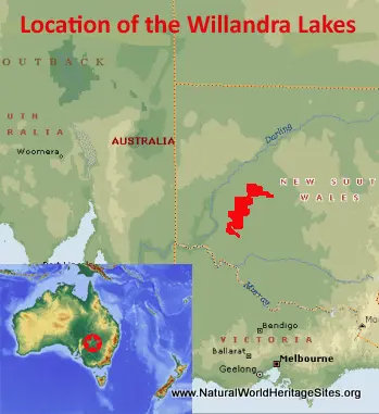
EXPLORE Australia’s Willandra Lakes Region with this slideshow, check the location map and get all the facts and information below.
For slideshow description see right or scroll down (mobile). Click to view slideshow
Location and Values: Australia’s Willandra Lakes Region is located in the Outback of New South Wales, about 100 km north-east of Mildura town. It covers a series of dried-up fossil lakes and the consolidated sand dunes that define the ancient shoreline. The primary significance of the Willandra Lakes relates to archaeological evidence of human occupation more than 50,000 years ago, making it one of the first places outside Africa to have been occupied by modern humans. The archaeological finds in the Region include three remarkable sets of Australian Aboriginal human remains, including the skeletons of the so-called ‘Mungo Man’ and ‘Mungo Woman’, who lived here about 42,000 years ago. The site reveals evidence of the earliest known human cremation, as well early use of grindstone technology. It also includes some remarkable human fossil tracks that record some moments, frozen in time, from the lives of an Aboriginal family and a group of hunters living around the lakeshores about 20,000 years ago, a little before the lakes dried up and finally disappeared 18,500 years ago. The present-day landscape provides a remarkable long-term record of past changes in climate and environmental conditions spanning a period of 100,000 years, including fossil evidence of the local fauna and extinction of Australia’s megafauna.
Conservation Status and Prospects. According to IUCN’s Conservation Outlook Assessment (2017) the conservation status of the Willandra Lakes Region is ‘good’. The IUCN report notes that the ‘World Heritage values appear to remain well preserved and stable and while some minor concerns exist, with minor additional conservation measures the site’s values are likely to be essentially maintained over the long-term. However, the condition and trend of some of the key attributes of the Outstanding Universal Value need to be better understood. The main conservation measure required is increased feral animal control and to reduce total grazing pressure on stabilizing vegetation. Additional management action and research is needed to address the threats posed by erosion, feral animals, total grazing pressure, increased visitor numbers and climate change. ’
Links:
Google Earth
Official UNESCO Site Details
IUCN Conservation Outlook
UNEP-WCMC Site Description
Birdlife IBA
Slideshow description
The slideshow ‘tells the story’ of Australia’s Willandra Lakes Region with a portfolio of photos by Peter Howard from a visit to Mungo National Park in December 2017. The photos start at the park’s visitor centre, where there is a modest display of some locally-used Aboriginal artefacts, recent history of European settlement and a small collection of mammalian fossils from the area. One of the most interesting items is a life-size model of Diprotodon, the largest marsupial mammal that ever existed in Australia (resembling a modern-day rhino) which was living in the area before its extinction. Given the global importance of the site, it is regrettable that so little attention is given to its human archaeological finds, but this may reflect the present-day aboriginal people’s ideas and respect for their ancient ancestors. Outside the small visitor centre is an open area – the ‘Mungo Meeting Place’ – where casts of the 20,000 year-old human tracks are embedded in the floor of an open amphitheatre, where Mungo’s indigenous peoples can gather as a community. A short walk away is a disused woolshed and sheep pens, now open for visitors to learn about the recent history of sheep farming in the area.
Leaving the visitor centre the following series of photos shows some of the scenery, vegetation and animals that are characteristic of the area, taking the 70 km loop road within the park, known as the Mungo Track. The track passes near ‘The Walls Lookout’ and climbs up through the sandy arc of the ‘Walls of China’ which was once the sand-blown shore of the ancient lake and the place where a wealth of archaeological finds has been made. Emus, kangaroos, various types of colourful parrot, lizards and other wildlife can be seen along the route, and there are opportunities to take a number of self-guided walks to learn about the dry mallee vegetation, the moving sand dunes of the ancient lake shore and a typical sheep-farming homestead dating from the recent European colonial era (the Zanci homestead). One of the most impressive activities of a visit to Mungo National Park and the Willandra Lakes Region is a guided walk onto the ‘Walls of China’ around sunset. Here visitors can see some mammalian fossils lying in the sandy substrate as the process of weathering by wind and rain gradually exposes them. To protect the fossils and prevent erosion visitors are only allowed into the area on one of these guided walks, which are especially memorable and photogenic at sunset. At this time the golden light of the setting sun catches the intriguing shapes of protruding sand and clay ‘castles’ derived from the ancient shore and now being progressively eroded.
The best way to get an idea of how the landscape might have looked 20,000 years ago when the lakes were full of water is to take to the air and a local operator provides short informative scenic flights around the dry Mungo lakebed and over the arc of dunes that marks its ancient eastern shore. From the air the dunes are clearly visible, as well as other landscape features, including the scars of recent human use for sheep farming. The slideshow ends with some scenes and animals encountered on the self-guided Foreshore Walk, where some useful interpretation boards are provided to help visitor’s understanding of the park and its present-day management.
Factfile
Website Category: Fossil Record
Area: 2,400 km2
Inscribed: 1981
Criteria:
- Fossil record (viii);
- Geological features (viii);
- Cultural criterion (iii)


