EXPLORE Nahanni National Park with this slideshow, check the location map and get all the facts and information below.

For slideshow description see right or scroll down (mobile). Click to view slideshow

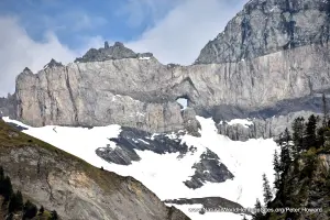
Location and Values: Nahanni National Park is located in the MacKenzie Mountains of Canada’s Northwest Territories, near the border with Yukon. It includes one of the most spectacular wild rivers in North America, featuring a series of deep canyons, and the huge Virginia Falls where the South Nahanni River crashes over a 90m precipice in a thunderous plume. The site is recognized for the complexity of its geological features, which include limestone caves, karst features and hot springs, as well as some spectacular granite peaks resulting from tectonic uplift. Nahanni was amongst the very first sites to be inscribed on the world heritage list (in 1978), and is now (since 2009) embedded within a much larger (30,000 km2) protected landscape, the Nahanni National Park Reserve.
Conservation Status and Prospects. According to IUCN’s Conservation Outlook Assessment (2017) the conservation status of Nahanni National Park is ‘good, with some concerns’. The IUCN report notes that the geological features of the site and its outstanding scenic beauty are well preserved and remain in a good condition. There are no significant threats at the moment, although a warming climate may result in increased permafrost thaw, and flooding. The most significant long-term potential threat is from mining activity in the wider landscape, which might impact the site.
Links:
Google Earth
UNESCO Official Website
IUCN Conservation Outlook
UNEP-WCMC Site Description
Slideshow description

The slideshow ‘tells the story’ of Nahanni National Park with a portfolio of photos by Sue Stolton and Nigel Dudley (Equilibrium Research) from a two-week visit in June 2010. They illustrate the landscape features of this outstanding place, starting with some aerial views, followed by a series of photos of the Virginia Falls. The slideshow documents a river journey along the South Nahanni River, through some of the steep gorges, and ends with more aerial photos showing the diversity of landscapes and habitats across Nahanni.
Factfile
Website Category:
Temperate & Boreal Forests;
Earth Features
Area: 4,765 km2
Inscribed: 1978
Criteria:
- Exceptional natural phenomenon (vii);
- Outstanding natural beauty (vii);
- Geological features (viii);