EXPLORE Los Alerces National Park with this slideshow, check the location map and get all the facts and information below.

For slideshow description see right or scroll down (mobile). Click to view slideshow

Location and Values: Los Alerces National Park is located in the Andes of northern Patagonia, along Argentina’s border with Chile. It is globally important in protecting a significant area of Patagonian (Valdivian Temperate) Forest, one of the world’s five types of temperate forest. This forest spans a significant range of altitude, with a corresponding diversity of ecological communities and species, in an excellent state of conservation. It includes significant areas dominated by the globally threatened Alerce tree which can live to more than 3,600 years, and is reckoned to be the second longest living tree in the world.
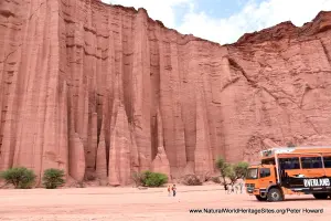
Although other areas of the Andes may be more scenically spectacular, the park includes a variety of outstanding landscapes and scenery. Amongst the lush forests there is a chain of interconnected lakes bounded by beaches and high cliffs, with crystal-clear rivers and gushing waterfalls. At higher elevations the mountain peaks are characterized by glacial features, with hanging valleys, moraines, glacial cirques and clear-water lakes.
Conservation Status and Prospects. According to IUCN’s Conservation Outlook Assessment (2017) the conservation status of Los Alerces National Park is ‘good’. The site is generally well managed, although a number of threats, including invasive species, livestock grazing, climate change and the impacts of tourism are affecting the site. The level of pressure from these threats remains low. There is a hydropower station and associated infrastructure in the buffer zone which has considerably altered parts of the site with the creation of a major impoundment, flooding parts of the lower-lying valleys in the south-east. However this predates the site’s inscription on the World Heritage List and its impact on the area’s outstanding biodiversity values is limited. The IUCN report notes that the impacts of tourism are expected to increase following the recent World Heritage Listing and this will require additional management measures.
Links:
Google Earth
IUCN Conservation Outlook
Official UNESCO Site Details
Birdlife IBA
Slideshow description

The slideshow ‘tells the story’ of Los Alerces National Park with a portfolio of photos by Peter Howard from a visit in January 2020. It illustrates the landscape features of this outstanding place, together with some of the typical plants and animals. Visitor access is relatively limited, with three entrance gates at strategic locations along the park’s eastern boundary, while the higher western two-thirds of the park is designated a strict scientific reserve and is off-limits.
The slideshow starts with a series of photos from the extreme south-eastern part of the park, where a short self-guided vehicle route includes a number of viewpoints and sites of interest. It continues by illustrating the diversity of features along the main park access road (Route 71) starting at the central entrance and proceeding north along the shores of Lake Futalaufquen and Lake Rivadavia to the northern entrance. The vegetation varies considerably from east to west across the park, the wettest parts lying along the Chilean border, with areas to the east (around the central entrance) lying in a semi-arid rain-shadow cast by the Andean cordillera. Here the vegetation is more characteristic of the dry Patagonian Steppe, but this soon gives way to Patagonian Forest vegetation communities across most of the park, with Valdivian Temperate Rainforest in the wettest parts along the Chilean border in the west. There are a number of short roadside trails to visit waterfalls and other features, and an opportunity to follow a picturesque forested trail crossing a wide pedestrian suspension bridge and following the banks of a glacial-blue river to a boat jetty (Puerto Chucao) at the south-eastern end of Lake Menendez. In mid-summer, the park is busy with visitors, most of them relaxing on the lake-shore beaches, while others enjoy some fishing, or take to the water in a canoe. For those looking for more strenuous activity there are 130 km of hiking trails through the forested mountains in the eastern part of the park.
The next part of the slideshow features a walk through some magnificent mature Nothofagus beech forest to a high viewpoint overlooking the small picturesque Lago Verde. Finally, the slideshow illustrates the park’s most popular excursion – a boat trip from Puerto Chucao to the north-western corner of Lago Menendez to see a gigantic Alerce tree, 2.2m in diameter and 2,600 years old. On the outbound journey the boat trip makes a short ‘diversion’ into the southern arm of the lake to view the face of a glacier, below the 2,253m peak of Cerro Torrecillos. The ancient Alerce tree is growing, with other smaller specimens nearby, in a multi-layered (Valdivian) temperate rainforest environment, with an understorey of bamboo and an abundance of lianas, mosses and epiphytes. This rainforest grows along the Chilean border where annual rainfall exceeds 3,000 mm, and is noticeably wetter than the other types of Patagonian Forest that grow in the drier rain-shadow conditions further east.
Factfile
Website Category: Temperate & Boreal Forests
Area: 1,884 km2
Inscribed: 2017
Criteria:
- Outstanding natural beauty (vii);
- Natural habitat for biodiversity (x);
- Significant number of rare, endemic and/or endangered species (x)