EXPLORE GÖREME NATIONAL PARK AND THE ROCK SITES OF CAPPADOCIA with this slideshow, check the location map and get all the facts and information below.

For slideshow description see right or scroll down (mobile). Click to view slideshow

Location and Values: Göreme National Park and the Rock Sites of Cappadocia are located in central Turkey, about 300 km south-west of Ankara, near the city of Nevsehir. The park protects a spectacular landscape of hoodoo landforms, eroded from soft volcanic tuff, with conical ‘fairy chimneys’, pinnacles, pillars, mushrooms and needles standing alongside multi-coloured cliffs and rock towers in the eroded valleys of a 1,000m-high plateau. These spectacular rock formations are derived from consolidated volcanic ash that was overlain by a layer of lava from three nearby volcanoes, providing a hard protective cap. The soft underlying rock is easily excavated and people have built underground homes and churches into many of the free-standing fairy chimneys, cliffs and towers since the 4th century, creating one of the world’s largest and most striking cave-dwelling complexes.
Conservation Status and Prospects. According to IUCN’s Conservation Outlook Assessment (2017) the conservation status of Göreme National Park and the Rock Sites of Cappadocia is ‘good, with some concerns’. The IUCN report notes ‘some concerns regarding excessive tourism impacts on the site. Göreme’s natural beauty was comparatively well preserved at the time of its inscription, however construction activities to accommodate the growing number of tourists visiting the site has put pressure on its scenic value. There is a need for more research to define tourism carrying capacity in order to improve visitor planning and tourism management. ’
Links:
Google Earth
UNESCO Official Website
IUCN Conservation Outlook
UNEP-WCMC Site Description
Slideshow description

The slideshow ‘tells the story’ of Göreme National Park and the Rock Sites of Cappadocia, focusing on the natural features of the area’s spectacular landscape. The series starts in the west of the site, at Uchisar, were there is a very fine collection of beautiful ‘fairy chimneys’ with a long history of human occupation, and a massive rock tower (‘Uchisar Castle’) pock-marked with caves and rooms at various levels like a giant apartment block, with tombs carved into the summit rock. From Uchisar the slideshow moves to Rose Valley (Gulludere), a popular place near Goreme village with some spectacular views of a landscape of pastel-coloured rocks and giant fairy chimneys. Amongst the tourist offerings, beach buggies and horse-riding are popular activities in this area as the setting sun casts its long shadow across the land.
Another popular way of enjoying the Cappadocia landscapes is by hot air balloon and the next few photos show just how crowded the skies can become when almost 200 balloons are launched around dawn each morning. From a photographic viewpoint the early morning launch is a little too early to catch the best light, as a typical flight only lasts an hour and the balloons are landing just as the sun begins to pierce the early morning mist. Nevertheless it’s an exhilarating experience.
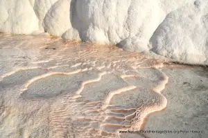
The second half of the slideshow covers some of the more popular parts of the park, including Love Valley (Gorkundere) with its spectacular phallic ‘needles’ rising sheer from the valley floor, and the capped pinnacles of Monk’s Valley (Pasabaglari). Two parts of the area with particular concentrations of fine cave architecture, churches and art are given special status and managed as open-air museums. These are shown in the next part of the slideshow, starting with the Zelve Museum (cliff-side dwellings around three inter-connected valleys) then the Goreme Museum with its fine churches and ecclesiastical art. There are further photos of Monks Valley (with its prominent St Simeon Dwelling) and Love Valley (with hot-air balloons seeming to touch the rock needles), before the last few photos showing a walking tour of Red Valley (Kizilcukur) with its pink and yellow ‘cascades’ of rock and fine isolated rock-cut churches.
Factfile
Website Category: Earth Features
Area: 99 km2 (Serial site)
Inscribed: 1985
Criteria:
- Outstanding natural beauty (vii);
- Cultural criteria (i, iii, v)