EXPLORE Durmitor National Park with this slideshow, check the location map and get all the facts and information below.

For slideshow description see right or scroll down (mobile). Click to view slideshow

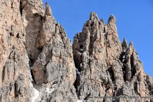
Location and Values: Durmitor National Park is located in the Dinaric Alps of northern Montenegro, on a spectacular limestone massif. The diverse mountain landscape covers an exceptionally wide range of altitude (from 450 to over 2,500 m) with 50 peaks over 2,000m. It encompasses a corresponding diversity of ecosystems and habitats, including rocky peaks, forests, alpine meadows, glacial lakes, rivers, caves and some of the deepest gorges in Europe. Its geology and geomorphology, much of it shaped by glaciers, includes remarkable karst phenomena, including savagely contorted limestone strata, deep caves and underground rivers, and dramatic gorges with sheer walls exposing magnificent rock formations. From a biodiversity perspective it provides sanctuary for many rare, endemic and iconic species such as Brown Bear, Grey Wolf, European Wild Cat and Chamois, as well as 130 species of birds, including Capercaillie and Black Grouse. A wide range of forest and grassland vegetation types occurs, with 700 vascular plant species recorded. Particularly valuable elements of the vegetation include an old-growth forest of European Black Pine (with 400 year-old specimens reaching a height of 50m) and some rich calcareous grassland communities with many rare and endemic species.
Conservation Status and Prospects. According to IUCN’s Conservation Outlook Assessment (2017) the conservation status of Durmitor National Park is of ‘significant concern’. The IUCN report notes that park management is severely constrained by inadequate financial and human resources to address the many threats. These include illegal logging, poaching and tourism activities within the site as well as threats originating beyond its boundaries. Durmitor is Montenegro’s primary ski resort area and related infrastructure developments threaten the park margins, while pollution from former mining activities (upstream on the Tara River) and the introduction of non-native fish species are other significant threats from outside the park. At the same time, a proposed new hydropower project could potentially have irreversible impacts on the site’s world heritage values and ecological integrity.
Links:
Google Earth
UNESCO Official Website
IUCN Conservation Outlook
UNEP-WCMC Site Description
Birdlife IBA
Slideshow description

The slideshow ‘tells the story’ of Durmitor National Park with a portfolio of photos by Peter Howard from a visit in May 2019, and additional material provided by Sue Stolten and Nigel Dudley (Equilibrium Research, who visited in July 2017). The photos illustrate the landscape features of this outstanding place, together with some of the typical plants and animals. Despite the steep terrain, there are a number of all-weather roads through different parts of the park and established driving ‘tour circuits’ that provide easy vehicular access to key areas, from where short walks can be made. The slideshow starts with scenes from the main east-west P14 road that traverses the park over the spectacular Sedlo Pass (1908m), where nearby peaks display some awe-inspiring contorted rock strata. During winter, while the lower mountain slopes around Durmitor are thronging with skiers, this pass is snow-bound and remains closed until late spring, when snow-drifts are cleared sufficiently to allow the passage of vehicles. At this time crocuses appear in great profusion and the alpine pastures come alive.
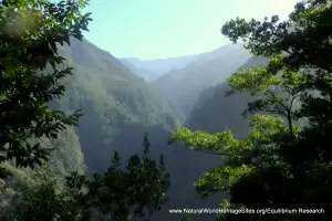
The next section of the slideshow features some of the exhibits in the park Visitor Centre near the Black Lake. This provides a useful introduction to the ecology of the place, including a selection of stuffed animals, insects and plant species that visitors might be lucky in the wild! The Black Lake and its surrounding forests and mountain peaks are shown, followed by views of the Tara River gorge, steeped in cloud, its flanks cloaked in dense forest. Some of this forest is subject to careful harvesting, using traditional methods involving extraction of logs by horse. The upland pastures in many areas within the park have been used by shepherds, some of whom still live in the area, and their traditional homes punctuate the alpine landscapes. The main feature of the western part of the park is the Susica river gorge, with its glacial lakes and remnant population of chamois.
The final part of the slideshow illustrates the lower-lying parts of the park, along the Tara River Gorge, starting at the Tara Bridge and following the P4 route towards Mojkovac. The Tara River cuts through a spectacular steep-sided gorge, with ancient beech forests hugging the river banks below exposed rock faces.
Factfile
Website Categories: Mountains; Temperate & Boreal Forests; Caves & Karst
Area: 321 km2
Inscribed: 1980 (extended 2005)
Criteria:
- Outstanding natural beauty (vii);
- Geological features (viii);
- Significant number of rare, endemic and/or endangered species (x)