EXPLORE Caves of Aggtelek Karst and Slovak Karst with this slideshow, check the location map and get all the facts and information below.
For slideshow description see right or scroll down (mobile). Click to view slideshow

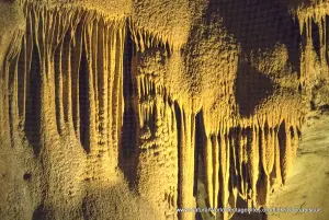
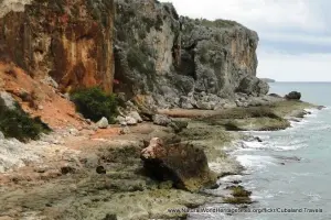
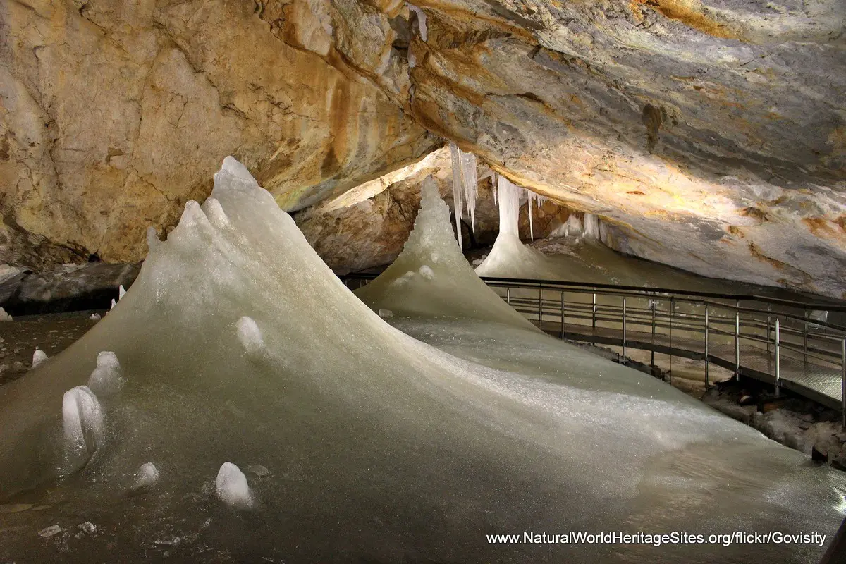
Location and Values: The Caves of Aggtelek Karst and Slovak Karst are located along the border between Hungary and Slovakia. Amongst the many cave systems in Europe this area is considered outstanding in terms of the number of caves that occur in a concentrated area. More than 1,000 caves have now been discovered and documented, with features that demonstrate changes in climatic conditions over long geological periods, including evidence of subtropical and tropical climatic conditions in the late Cretaceous and Tertiary periods as well as glacial climates in more recent times. The most significant cave system is the Baradla-Domica complex which includes an underground river, a cavern 50m in diameter (that can accommodate 1,000 people!) and the world’s tallest stalagmite (standing at 32.7m). The Baradla-Domica system straddles the international border and is richly decorated with speleothems (cave formations such as stalactites and stalagmites). Further north, as a separate component of this serial site, is the Dobsinska Ice Cave, where a permanent underground glacier is decorated with ice stalagmites created through the freezing of local drip waters. Elsewhere and above ground, typical karst features are in evidence and these are particularly well demonstrated in the area of Zadielska Gorge in the east of the site.
Conservation Status and Prospects. According to IUCN’s Conservation Outlook Assessment (2020) the conservation status of the Caves of Aggtelek Karst and Slovak Karst is ‘good’. The caves are protected within Hungary’s Aggtelek National Park, and Slovakia’s Slovak Karst and Slovensky Raj National Parks. About 1% of the caves are open to the public as ‘show caves’, while the remainder of the site is unaffected by human activity and remains pristine. In the long term, there is a need to provide integrated development planning and protection for the entire water catchment, with a particular focus on preventing possible pollution of cave waters and managing any infrastructure developments in the area. The Dobsinska Ice Cave is clearly vulnerable to a warming climate as it exists on the climatic/latitude/geographic margins that can support such a cave feature.
Links:
Google Earth
Official UNESCO Site Details
IUCN Conservation Outlook
UNEP-WCMC Site Description
Birdlife IBA
Slideshow description

The slideshow ‘tells the story’ of the Caves of Aggtelek Karst and Slovak Karst with a portfolio of photos that illustrate the three main features of the site. It starts with a series of photos from the highly decorated interior of the Baradla cave system, showing the variety of stalagmites, stalactites and other cave formations that can be seen within the visitor ‘show caves’. It continues with a series of photos from the Dobsinska Ice Cave, and continues with a series showing the karst landscape features above ground, in the area of the Zadielska Gorge.
The following Flickr photographers are acknowledged with thanks for their contributions to this slideshow: Janos Korom, Govisity, Laszlo Daroczy, Peter Fenda, Phil Blackburn, Simon Watt and Karoly Szantai.
Factfile
Website Category:
Caves & Karst
Area: 567 km2
Inscribed: 1995
UNESCO Criterion:
- Geological features (viii);