EXPLORE Tikal National Park with this slideshow, check the location map and get all the facts and information below.
For slideshow description see right or scroll down (mobile). Click to view slideshow

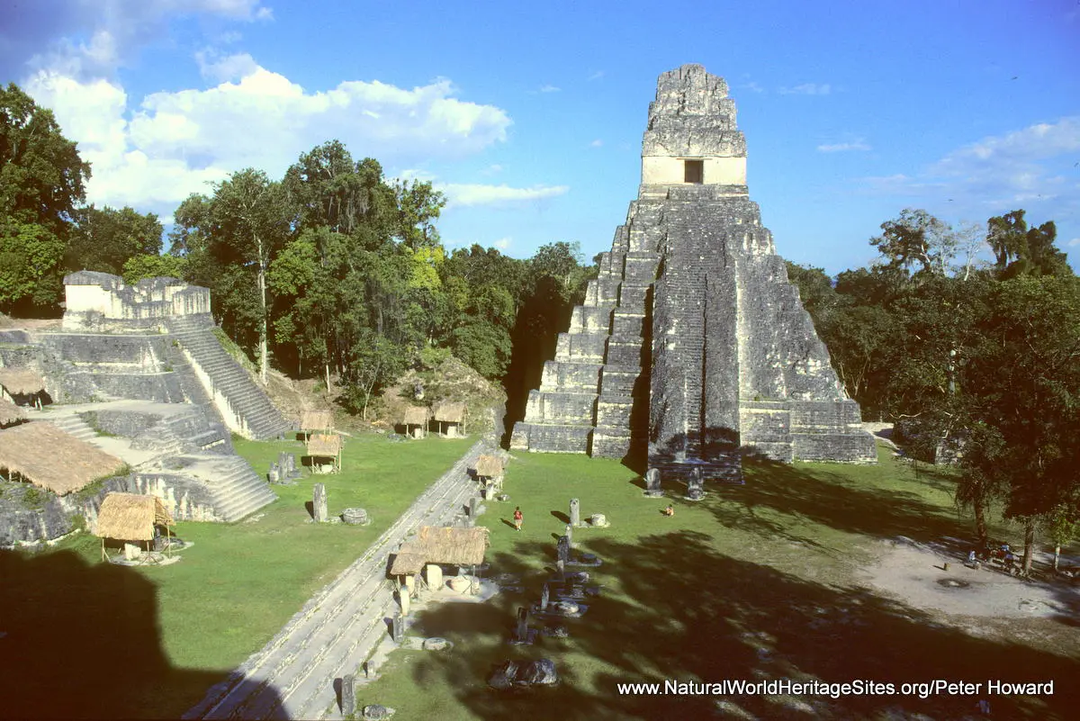
Location and Values: Tikal National Park is a mixed natural/cultural site located in northern Guatemala, close to the border with Mexico. The park lies at the core of the vast Maya Forest, a major biodiversity hotspot that covers much of the Yucatan peninsula, stretching into southern Mexico and Belize. In ancient times this area was heavily settled and served as a major centre of Mayan civilization from around 600 BC until its downfall around 900 AD. Today it is one of the most important archaeological complexes of the Mayan era, with massive temples and palaces, public squares and the remains of residential buildings embedded deep in the jungle. Forests have reclaimed much of the land that was settled by the Mayans, and this semi-natural ecosystem continues to demonstrate ongoing ecological processes associated with past disturbance. Nevertheless the diversity of natural habitats is remarkable and includes wetland, savanna, broadleaf forest and palm forests with an impressive diversity of flora and fauna. There are more than 100 species of mammal, including rare and endangered species such as jaguar, Baird’s tapir and Yucatan spider monkey. Ocellated turkey and Great Curassow are notable amongst the recorded 330 bird species.
Conservation Status and Prospects. According to IUCN’s Conservation Outlook Assessment (2017) the conservation status of Tikal National Park is ‘good, with some concerns’. The IUCN report notes that ‘the declaration of the protected area and the simultaneous status as an archaeological site has buffered Tikal National Park from the profound landscape transformation in parts of the Petén region over the last decades. Nevertheless, as demand for land, pasture and natural resources is increasing so are the many threats, such as excessive poaching and harvesting, as well as fires. Tourism likewise runs the risk of exceeding the capacity of the property in the most visited areas. The threats from anticipated climate change and proposals for road construction in and near the property add further question marks. ’
Links:
Google Earth
UNESCO Official Website
IUCN Conservation Outlook
UNEP-WCMC Site Description
Birdlife IBA
Slideshow description

The slideshow ‘tells the story’ of Tikal National Park, showing the archaeological site and surrounding forest habitats, plants and animals. Many of the photos focus on the archaeological site, where the intimacy of the place is quickly felt: some of the ruins remain buried in the jungle, while other monuments have been excavated and restored. It is a wonderful justaposition of wild nature and ancient civilization.
In addition to photos by Peter Howard, the following Flickr photographers are acknowledged with thanks for their contributions to this slideshow: 4Neus, Bernard Dupont, Daniel Mennerich, David Gomez, Diana Broeders, Diego Aviles, E.P. Mallory, flx.flx, Gautier Poupeau, Hectorlo, kowari, Kurt Bauschardt, Laurent de Walick, Mederic, Phil, Ramon, Steve Hanna and Tom Bradnock.
Factfile
Website Category: Tropical & Sub-tropical Forests;
Area: 576 km2
Inscribed: 1979
Criteria:
- Ecological processes (ix);
- Natural habitat for biodiversity (x);
- Significant number of rare, endemic and/or endangered species (x)
- Cultural criteria (I, iii, iv)