EXPLORE Swiss Tectonic Arena Sardona with this slideshow, check the location map and get all the facts and information below.
For slideshow description see right or scroll down (mobile). Click to view slideshow

Location and Values: The Swiss Tectonic Arena Sardona covers a small area of the European Alps in north-east Switzerland, where the processes of mountain building resulting from the collision of Earth’s tectonic plates were first recognized. In particular, early observations and geological mapping of this area resulted in a detailed understanding of the mountain-building process of thrusting, in which deeper, older rocks are carried over younger, shallower ones. In the Swiss Tectonic Arena the rock strata that reveal this process are clearly evident to non-specialists and can be easily observed by visitors. Here older rocks from the Permian era have been thrust over younger strata from the Upper Jurassic, Cretaceous and Tertiary periods, forming a hard, erosion-resistant ‘cap’ on the highest mountains. Subsequent glacial activity has cut through the rocks, exposing the rock strata. The early scientific observations of the ‘Glarus Overthrust’ at this site helped inform our understanding of how the Alps were formed through collision of the African and European tectonic plates, and how similar fold-mountain belts arose elsewhere around the world.
Conservation Status and Prospects. According to IUCN’s Conservation Outlook Assessment (2017) the conservation status of the Swiss Tectonic Arena Sardona is ‘good’. The IUCN report notes that the geological attributes of the site are inherently robust, inaccessible and unlikely to be affected by human activities. It commends the careful selection of suitable boundaries for the world heritage site and notes that the site benefits from highly effective management.
Links:
Google Earth
UNESCO Official Website
IUCN Conservation Outlook
UNEP-WCMC Site Description
Slideshow description

The slideshow ‘tells the story’ of the Swiss Tectonic Arena Sardona with a portfolio of photos by Peter Howard from a visit in June 2019. The slideshow begins near the site’s western boundary at Lochsite, a readily accessible location where the interface between the older rock strata (above) and younger ones (below), can be observed. This is one of the classic sites where the Glarus Overthrust is best illustrated by a distinct boundary line between strata and a narrow band of contorted rock resulting from friction as the older rocks were thrust over younger strata during collision of the Earth’s tectonic plates during the period when the Alps developed.
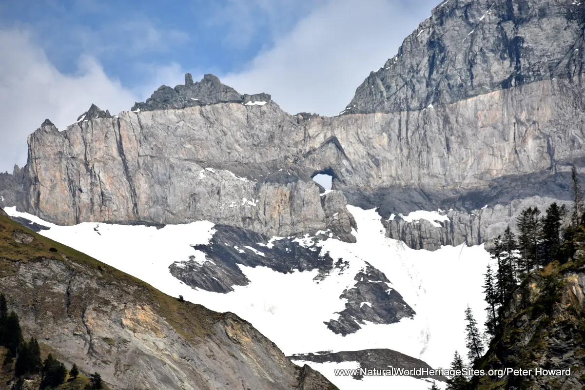
A little further south the area around the village of Elms provides the best location to observe the scale and features of the Overthrust. From here distant views of the sheer mountain cliffs of the Tschingelhorner ridge can be seen, with the distinct strata of older rocks lying on top of younger ones. Curiously, the main cliff here features an unusual natural ‘window’, a hole known as Martinsloch. Access to the mountain summit, where the Overthrust features can be examined and experienced at close quarters, is best during the months of high summer (July – September) when the mountain summits are clear of snow and cable cars are operating.
The slideshow provides context for the site with some photos of the picturesque Swiss villages and alpine pastures in the valleys bordering the site, and continues with some photos of educational and visitor facilities that help provide some understanding of the site’s global importance. Three such centres are shown, starting with the natural history museum in the town of Chur (where there is a wonderful high-tech 3D interactive model of the site, as well as stuffed animals from the region and extensive geological exhibits of more general interest); followed by the visitor advice centre in the old railway station building at Glarus; and finishing with the informative exhibition about the site in the visitor centre at Elms.
Factfile
Website Categories: Earth Features;
Area: 328 km2
Inscribed: 2008
Criteria:
- Geological features (viii);