
EXPLORE the Boma-Badingilo Migratory Landscape with this slideshow, check the location map and get all the facts and information below.
For slideshow description see right or scroll down (mobile). Click to view slideshow
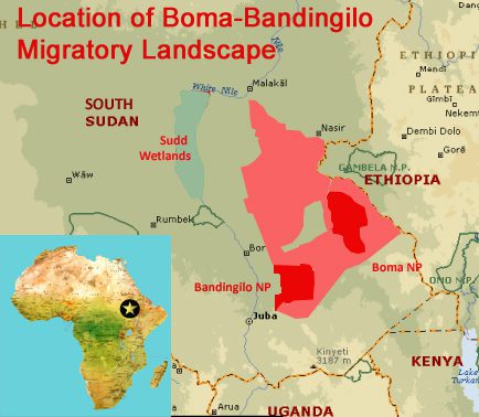
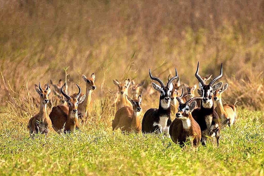
Location and Values: The Boma-Badingilo Migratory Landscape is a vast area of fire-maintained grasslands, floodplains, seasonal wetlands and wooded savannas, in the southeast of the newly-established nation of South Sudan. It supports the world’s greatest large mammal migration, involving about 6 million antelopes moving over vast distances in seemingly endless herds as the rains, floods and fires dictate. It is undoubtedly one of the world’s greatest wildlife spectacles, and one of its most tightly-held secrets.
Although the migration has been known to the outside world since the 1970s, decades of brutal internal conflict across (formerly unified) Sudan have prevented knowledge of it reaching those outside the country. Now, with the dawn of the new nation of South Sudan bringing an era of relative peace and stability the ‘Great Nile Migration’ is once again in the international spotlight. And, in recognition of the opportunity to conserve an entire migratory landscape, this has become the world’s single largest terrestrial World Heritage Site – three times the size of Switzerland – and South Sudan is custodian of a larger expanse of World Heritage property than any other nation except the Russian Federation.
Recent aerial census work and radio-collaring of animals has provided extraordinary new insights into the scale of the migration and the routes used by the various species involved. Key findings include the following:
- The migration occurs over a vast area of at least 120,000 km². Most of this area is sparsely populated with tribal peoples living a very traditional lifestyle based on cattle keeping, while about a quarter of the area (28,682 km²) is designated for wildlife protection within the Boma and Badingilo National Parks;
- The migration involves four main antelope species including about 5.1 million white-eared kob, 300,000 tiang, 350,000 Mongalla gazelle, and 160,000 Bohor reedbuck. Altogether, these four species total about six million individuals making it the largest land mammal migration on Earth;
- Different species use the landscape in different ways, following quite distinct migration routes (as reported by the Global Initiative on Ungulate Migration, see link below) ;
- White-eared kob is the most numerous species, and collaring of 85 animals of this species has revealed four distinct migration routes between wet and dry season ranges, involving movements of 50-300 kilometres. Some of these animals cross the international border into Ethiopia’s Gambela National Park;
- Tiang seem to follow a more predictable north-south migration route to the east of the Nile floodplains, averaging 180 km in length;
- Animals of all species disperse widely across the landscape during the wet season, mostly in the south, moving to areas with permanent water, such as the margins of the Sudd wetlands to the north and parts of Boma National park during the dry season;
- Some non-migratory species that were abundant in parts of the landscape in the 1970s and 80s (when previous animal censuses were carried out) such as zebra and black rhino have been hunted to extinction, while populations of other more sedentary species (such as elephant, hippo, buffalo, cheetah and warthog) have been reduced by as much as 95%.
Conservation Status and Prospects.
The Boma-Badingilo Migratory Landscape was inscribed on the World Heritage List under Emergency Procedures and immediately placed on the List of World Heritage In Danger. The migratory herds face numerous serious threats as the new nation of South Sudan strives for peace, security and economic development. The main threats are:
- Hunting for subsistence use and a growing commercial trade in bushmeat. This is the greatest current threat, facilitated by the widespread availability of guns and increasingly easy access to ‘hunting grounds’ that were previously too dangerous to enter due to civil and inter-tribal conflict. For decades insecurity over most of the migratory landscape has driven people into tight defensive settlements, allowing the migrating herds ‘free range’ over most of the unoccupied landscape. Now, with the relative peace, settlements are expanding and hunters are able to move more freely across the landscape while also having easier access to local and international bushmeat markets;
- Insecurity, sporadic episodes of political unrest and inter-tribal conflict. Whilst the establishment of South Sudan as an independent nation in 2011 has heralded an era of relative peace and stability there remain sporadic episodes of unrest and conflict, undermining many economic and social development activities. It is not safe for tourists to visit the two national parks or other parts of the landscape so this potential source of development, jobs and income remains elusive. Meanwhile some in-disciplined armed groups exploit wildlife from areas around their camps to feed themselves and as a source of income supplying commercial markets.
- Inadequate institutional capacity and investment in conservation. Whilst the traditional practices and lifestyle of the tribal peoples who share the migratory landscape has enabled co-existence of wildlife and people for millennia, the development of a modern state and breakdown of some cultural traditions requires the integration of more formal conservation practices. South Sudan inherited Boma and Badingilo National Parks as ‘core’ areas of the migratory landscape, but these parks only cover a quarter of the area and have only recently come under active management, through a public-private partnership arrangement with the international organization African Parks. There is currently very little management infrastructure, road access or facilities in either of the parks, so patrol and protection work is carried out from the air. Meanwhile, three quarters of the landscape has no formal conservation status. New community-based management systems (such as the ‘conservancies’ established elsewhere in Africa) may provide a mechanism to ensure conservation of the wider landscape but this concept is yet to be ‘tried and tested’ and needs to be part of a wider land-use planning exercise. Given the scale of the challenge, this will require an enormous sustained investment.
- Habitat fragmentation. At present the Boma-Badingilo Migratory Landscape is an unbroken expanse of natural habitat, allowing the Great Nile Migration to continue unimpeded as it has for millennia. But this is changing, with the upgrading of road infrastructure, expansion of urban settlements and potential for new cattle fences and other linear infrastructure development. The impact of habitat fragmentation has been demonstrated around the settlement complex at Pibor in the core of the migratory landscape. Here, radio-collared animals have established migration routes that skirt around the town and surrounding fields but it will become increasingly difficult to sustain landscape connectivity as further development continues.
- Oil exploration. South Sudan is one of the most oil-dependent economies in the world, with oil providing 90% of government revenue and 95% of export income. Oil exploration licenses have been awarded for large parts of the landscape, including most of Badingilo National Park and (most importantly) other parts of the Tiang migratory range. Oil exploration and exploitation is incompatible with World Heritage status, and it is essential to ensure that the migratory landscape is maintained free of such activity;
- Possible future water management schemes. Whilst it is not an immediate threat, there is clearly potential for development of large-scale drainage, agricultural development and other schemes such as the partially-constructed Jonglei Canal that would impact the migration in significant ways.
Links:
Google Earth
Slideshow description
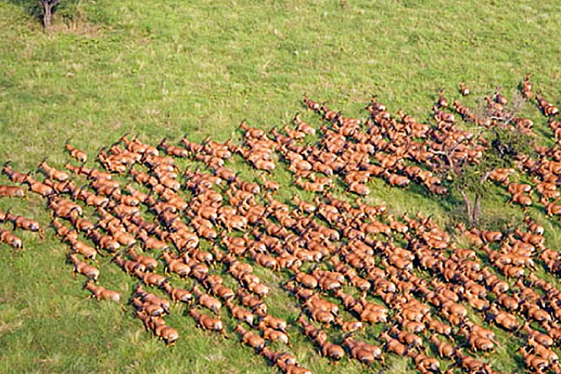
The short slideshow starts with images of the two most prominent species involved in the Great Nile Migration (White-eared Kob and Tiang) including some aerial shots of massed herds of Tiang on migration. Maps are included showing (1) the extent of the migratory landscape in relation to the existing protected areas of Boma, Badingilo and Gambela National Parks, and (2) the different migration routes followed by White-eared Kob. The main part of the slideshow features other key species, including elephants and giraffe as well as a number of landscape and habitat views. The images are taken from various internet sources without proper photo credits, but recognition is due to African Parks and Wildlife Conservation Society photographers with special mention to Marcus Westberg. A wealth of further images is available via the African Parks and National Geographic websites (see links below).
Factfile
Website Category:
Tropical & Sub-tropical Savannas & Woodlands
Area: 112,500 km²
Inscribed: 2026
Criteria:
- Exceptional natural phenomenon (vii);
- ecological processes (ix);
- natural habitat for biodiversity (x);
- significant number of rare, endemic and/or endangered species (x)
