EXPLORE NIGER’S W-ARLY-PENDJARI COMPLEX with this slideshow, check the location map and get all the facts and information below.
For slideshow description see right or scroll down (mobile). Click to view slideshow

Values: Since its extension in 2017 (based on the previously inscribed W National Park of Niger) the re-named site of W-Arly-Pendjari complex comprises a trans-frontier protected area covering a complex of reserves clustered across the international border between Niger, Benin and Burkina Faso. The W-Arly-Pendjari complex supports the largest remaining population of elephants in West Africa, and provides one of the most complete examples of a West African savanna woodland ecosystem. The W-Arly-Pendjari complex lies in the transition zone between the Sudanese and Sudano-Guinean savannas and is predominantly semi-arid to semi-humid Sudanese wooded savanna. Flooded plains along the Niger River lie under a major Palaeoarctic-Afrotropical flyway and between February and May over 20,000 aquatic birds congregate there.
A comprehensive review of the world heritage values of the W-Arly-Pendjari complex is provided below, together with details of the area’s conservation status and the threats it faces.
REVIEW OF WORLD HERITAGE VALUES: According to IUCN’s Conservation Outlook Assessment (2014), the specific attributes which qualify the W-Arly-Pendjari complex for world heritage status can be summarised as follows:
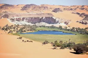
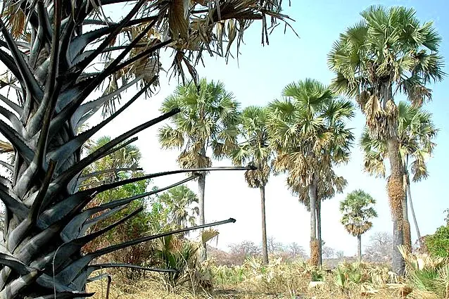
Wide variety of aquatic and terrestrial ecosystems within a large protected area complex. The W-Arly-Pendjari complex straddles three major biogeographical regions (Sudano-Guinean, Sudanese and Sahelian) and supports a correspondingly diverse range of habitats. These include wetlands of international importance (associated with the Niger River and its tributaries and floodplains) as well as gallery forests, wooded savannas, semi-desert scrub and magnificent stands of giant Baobab trees. The size of the extended W-Arly-Pendjari complex provides it with ecological resilience and should ensure the maintenance of its outstanding value as one of the few remaining relatively intact savanna ecosystems in west and central Africa.
High diversity and biomass of plant and animal species. The W-Arly-Pendjari complex supports a relatively high diversity of plant and animal species, especially when considered within a sub-regional context. The fauna includes 73 species of mammals and one of the largest populations of wild ungulates in west Africa. There are 367 species of birds recorded in the W-Arly-Pendjari complex as well as 112 species of reptiles, 120 species of fish (fauna representative of the Niger River) and 500 species of higher plants.
Important over-wintering site for Palaearctic birds. The W-Arly-Pendjari complex has a particularly rich birdlife and serves as an important migratory stop-over and over-wintering site for various species including ducks, geese, swans, herons, bitterns and storks which spend the northern summer in Europe.
Habitat of rare and endangered species. Some of the very few remaining west African populations of endangered large mammals occur in the W-Arly-Pendjari complex, including wild dog, cheetah, lion, leopard, elephant, African manatee and red-fronted gazelle.
CONSERVATION STATUS AND PROSPECTS: The conservation status of the W-Arly-Pendjari complex is of significant concern as there has been a progressive degradation of the park’s resources over several decades. Although the values which justified the site’s inscription on the World Heritage List are still present, they have been significantly compromised. Populations of key species have been reduced and the park is facing growing pressures for agricultural land, harvesting of non-timber forest products and bushmeat from fast-growing communities outside its boundaries.
MANAGEMENT EFFECTIVENESS: The management authority does not have enough financial, technical and material support to address the growing number and intensity of threats and ensure effective management of the various reserves that make up the W-Arly-Pendjari complex. Poaching remains a major challenge which the authorities have been largely unable to stop. There are significant unresolved issues regarding the legal status and location of boundaries, as well as the definition and management of buffer zones. International cooperation over management of the wider protected areas complex is being supported through international aid, but some problems originating beyond the park’s boundaries – such as siltation of the Niger River – remain as serious unresolved challenges.
REVIEW OF CONSERVATION ISSUES AND THREATS: The following issues represent specific threats to the ecology, conservation and values of the W-Arly-Pendjari complex world heritage site.
- Poaching (illegal hunting for subsistence and commercial use). Significant levels of poaching (hunting and fishing) are affecting many areas within the W-Arly-Pendjari complex (although this has been reduced in recent years). In areas of high commercial poaching pressure (especially near the Niger and Mekrou Rivers) wildlife viewing by tourists has become difficult as animals are increasingly wary of people.
- Grazing of domesticated animals. Areas within the W-Arly-Pendjari complex are frequently subject to illegal grazing by cattle and other domestic livestock brought into the park by members of local communities and trans-humance societies. This deprives wildlife of forage, degrades the natural habitats within the reserves and drives wildlife into ‘safer’ areas. The pressure of illegal grazing has been significantly reduced in recent years through improvements in pastoral areas outside the park combined with better park boundary demarcation and creation of a designated corridor to allow for cattle movements through the park in a controlled manner. Awareness campaigns and increased monitoring and enforcement have also helped, with the support of international aid through the ECOPAS Programme and other partners such as Africa 70.
- Agricultural encroachment. Several areas within the W-Arly-Pendjari complex have been occupied and cultivated illegally, including islands in the Karey Kopto area, parts of the river floodplains around Tapoa village and riverine areas around the village of Baniguitti (which serves as a natural border between Niger and Burkina Faso). There is growing pressure for agricultural land and other resources around the periphery of the W-Arly-Pendjari complex as the human population continues to grow and this could easily spill over into the park.
- Community use of resources. The harvesting of non-timber forest products (medicinal plants, fruits, etc.) is carried out within the W-Arly-Pendjari complex by members of local communities. Where this is carried out on a subsistence basis, extraction is generally sustainable and does not significantly threaten the park.
- Erosion and siltation. Land-use pressures and poor land management practices in the Niger River catchment upstream of the W-Arly-Pendjari complex have resulted in increased siltation of the river and some deposition of silt on the floodplains and wetlands within the park. The possible impact of this increased siltation and deposition on the ecology of the park has not been evaluated.
- Invasive alien species. The emergence of invasive plants such as Typhas reeds and water hyacinth has been observed in the nearby Dosso Reserve (which forms part of the park’s buffer zone). This clearly represents a potential threat to the important wetland habitats of the complex, which could potentially be ‘taken over’ by these invasive species with the loss of indigenous species.
- Fire. Fire is widely used by local farmers and herders to clear unwanted vegetation and stimulate early growth of pasture for domestic stock grazing. These deliberate fires sometimes get out of control and spread into the W-Arly-Pendjari complex where they can cause significant damage under certain circumstances (recognising that fire is a natural part of ecosystem dynamics in this area).
- Dam construction. A proposed dam at Dyodyonga is a potential threat as it would flood some of the botanically-important gallery forests along the Mekrou River (as well as some of the region’s major archaeological sites in Niger and Benin).
- Mining. Although there are no immediate, specific plans for mining in the W-Arly-Pendjari complex or its vicinity, the government of Niger has indicated a general intention to pursue mining opportunities in the area (which is thought to be rich in phosphate and gold resources).
- Displacement of Tapoa community members. The proposed upgrading of a major road near Niger’s W National Park boundary at Tapoa is likely to result in displacement of some members of the community. This could potentially result in greater pressure for agricultural land and resources from within the park.
- Water Pollution. There is a growing threat of pollution from possible future mining operations and/or domestic sewerage associated with expansion of the settlement at Tapoa.
Links:
Google Earth
IUCN Conservation Outlook
UNEP-WCMC Site Description
Official UNESCO Site Details
Birdlife IBA
Slideshow description

Slideshow Description: The slideshow provides a comprehensive overview of the W-Arly-Pendjari Complex, which straddles the international border between Niger, Burkina Faso and Benin. It shows the area’s wooded savanna landscapes, wildlife habitats, plants and animals while highlighting some of the conservation management issues, and illustrating local community livelihoods and some typical visitor experiences.
Factfile
Website Category: Tropical & Sub-tropical Savannas & Woodlands
Area: 17,148 km2
Inscribed: 1996 (extended 2017)
Criteria:
- (ix) ecological processes,
- (x) biodiversity