EXPLORE QINGHAI HOH XIL with this slideshow, check the location map and get all the facts and information below.

For slideshow description see right or scroll down (mobile). Click to view slideshow

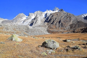
Location and Values: Qinghai Hoh Xil is located on the high Qinghai-Tibetan Plateau in central Asia and comprises a vast frozen wilderness of high mountains and steppe at elevations above 4,500m. Larger than the US State of Massachusetts and almost the size of Switzerland, this vast area is a treeless wilderness punctuated by a concentration of freshwater lakes, fed by glacial melt-waters from towering snow-covered mountains. The extreme climatic conditions on the plateau have nurtured a unique biodiversity with a third of the plant species and 60% of the area’s mammals endemic to the plateau. One of the world’s last great mammal migrations – involving tens of thousands of endangered Tibetan antelope – takes place here each year, while other notable mammals include wild yak, Tibetan wild ass, Tibetan gazelle, wolf and brown bear.
Conservation Status and Prospects. According to IUCN’s Conservation Outlook Assessment (2017) the conservation status of the Qinghai Hoh Xil is ‘good, with some concerns’. The IUCN report notes that ‘the cumulative effects of the different threats needs an efficient and targeted monitoring system and related management responses. The protection is in place but it needs to be more coordinated with the surrounding protected areas and other economic development policies (transportation, energy) to be effective. ’
Links:
Google Earth
Official UNESCO Site Details
IUCN Conservation Outlook
Slideshow description

The slideshow ‘tells the story’ of Qinghai Hoh Xil as seen from the only surfaced road through the area, the main (G109) national road that crosses the plateau in a north-south alignment. This road runs through the east-central portion of the world heritage site, although most of the terrain on either side of it (and an adjacent railway line) is designated as buffer zone due to the impact of this transport corridor on the landscape and natural wilderness values. Nevertheless the road provides rare access to a difficult, inhospitable environment, where only the hardiest of travelers are likely to venture!
The road journey covered by the slideshow was undertaken by Peter Howard in August 2004, in a self-contained commercial overland ‘expedition’ truck, travelling between the Tibetan capital of Lhasa and the Silk Road oasis town of Dunhuang. The slideshow includes some photos from parts of the Tibetan plateau that lie slightly outside the world heritage site, but are used to illustrate the main features of this harsh, spectacular landscape.
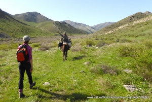
The slideshow starts on the southern fringes of the world heritage site where Tibetan herders use the short summer months to graze their stock on the high pastures, against a backdrop of high snow-covered peaks. The herders’ traditional means of transport is on horseback, but powerful motorbikes are increasingly the transport of choice. During the brief summer months melt-waters can easily wash out culverts and make motorized transport of any kind challenging, while night-time temperatures far below zero create special problems for starting cold diesel engines – which can be solved by covering the engine with a thick layer of blankets and burning an open fire below!
The vegetation across the plateau is characterized by a variety of grasses and succulent cushion plants, adapted to the freezing temperatures and wind chill. Amongst this low swathe of vegetation, the endemic burrowing Ladak Pica is able to survive, diving underground to escape predators. In mid-summer a complex patchwork of lakes and wetlands punctuates the landscape, used seasonally by a variety of migrant waterbirds and waders. Journeying north the landscape becomes increasingly dry as the road reaches the edge of the North Tibetan Plateau-Kunlun Mountains alpine desert, and the shores of seasonal lake beds are marked by encrustations of salt and cracked mud.
Factfile
Website Category: Temperate Grasslands, Steppes, Shrub-Lands & Tundra
Area: 37,356 km2
Inscribed: 2017
Criteria:
- Exceptional natural phenomenon (vii);
- Outstanding natural beauty (vii);
- Natural habitat for biodiversity (x);
- Significant number of rare, endemic and/or endangered species (x)